Tuesday 27 October 2009

Youngest British women to climb Everest passes ML


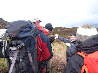
Tori James (pictured centre), the youngest British women to climb Everest when she was 25 back in May 2007, has passed her Mountain Leader summer award. Well done Tori!

I asked her and her two ML trainee friends, Sam (left) and Verity (right), about how their training went. Watch the blog for more on how Tori's Assessment went.

What is your definition of a Mountain Leader (ML)?
T: someone with excellent navigation skills and extensive experience of walking in mountainous areas
S: someone who encourages others to enjoy the mountains
V: a good communicator who can ensure the safety of others in the mountains

Why are you doing your ML training?
T: to enable me to work with Gold D of E Groups and lead expeditions overseas
S: to lead groups on overseas expeditions e.g. for the British Schools Exploring Society
V: to feel confident in my outdoor skills

Which books did you buy to swot up?
Hill Walking (Steve Long)
Mountaincraft & Leadership (Eric Langmuir)
Hostile Habitats – Scotland’s Mountain Environment (Mark Wrightham)

What are your top 3 mountain leader kit essentials?
T: good lightweight waterproofs, group shelter, first aid kit
S: spare hat & gloves, zinc oxide tape, head torch
V: dried apricots & nuts, thermos flask, good map case

Your best advice for Trail readers thinking about doing their ML?
T: consider doing an entry level qualification first e.g. the Basic Expedition Leader Award (BELA) or the Walking Group Leader Award (WGL).
S: get some voluntary experience e.g. with D of E or Scouts
V: book yourself onto the ML training course

Pace counting uphill


Your 100m pace count obviously goes up with increasing gradient, but how do you work out how much it increases by?

Navigating through North Snowdonia as outlined in my last post, I totally messed up getting to my second weird contour because I didn't know how far I had walked. My timing was out as I had kept stopping to look at the map or box round gorse and rocks, so I was relying on my distance being right...and it was wrong...

On my ML training course with Stuart Johnston Mountaineering, Mountain Instructor Derek Bain showed us an ingenious way to work out your 100m pace count for different gradients using a box that you pace out.

First, choose gradient level, say 2x10m contours over 50m. Mark a spot with a stone. Pace 50m up the slope. Turn 90 degrees left and pace 50m along the slope. Turn 90 degrees left again and pace 50m down the slope. Turn 90 degrees left again and pace 50m back along the slope.

If you are now back at your backpack, the slope had no affect on your pacing. If you are now lower down the slope than your backpack then you need to add some more paces on for the uphill section. Count the paces it takes to walk straight up to your backpack and add them on to your uphill count for 50m. Double this for an uphill 100m pace count for your gradient.

Weird Welsh contours


Finding weird-looking contour lines on your map and navigating over to investigate them is a great way to practice for your Mountain Leader summer award.

This weekend I went to find some on the oddly curving hillside near Drum in Northern Snowdonia.

After a quick 100m pace check I started walking on bearings through often impenetrable heather and spiky gorse with a relatively easy prominent spur edged with crags, got lost on an obvious-looking re-entrant and ended with a bowl-shaped feature.

I learned several really useful things:
  • Allow plenty of time - I picked 5 or so features and was out for 3 hours!
  • Aspect of slope is a useful tool for confirming which part of the slope you are on
  • Practice your 100m pace-count on different uphill gradients
  • A knitting counter is useful for remembering how many 100ms you have walked
  • Does anyone know a good place to put your compass if you need to use that hand and don't have a pocket? I slide mine under a backpack strap but it sometimes moves the bezel
  • Know your scale - how big is a 25m feature in real life? Will features even make it on to a 1:25,000 map with 10m contour intervals?
  • Having an ML buddy to confirm you have actually navigated to the right feature is a bonus. My friend couldn't make it in the end and it would definitely have been better with a pal
  • Don't take your non-ML friends unless they really really like you. I don't think any of mine would have followed me through all those gorse bushes!
Two of the above really stand out and I'll go through that in more detail in my next two posts.

Looking at the landscape at this level of detail was really eye-opening. I now use contours to navigate much more of the time, and practice makes you quicker at working out how long it should take you to your next destination, what you should see on the way and what you should arrive at. It needs a lot more practice, but I'm getting there.

Thursday 10 September 2009

Getting outside

Finally, I have two trips planned to practice everything I learnt on my ML training course with Stuart Johnston Mountaineering back in April. I just hope I haven't forgotten it by now!

One tip Stuart gave me to boost your efficiency when practicing is to go with another ML trainee. This way you can both check each other's navigation and test each other on those easily over looked skills like using a rope, river crossings, first aid and your knowledge of the mountain environment.

So my ML trainee friend Sara and I will hit Wales next month to nail our micro navigation on some hills we've never seen before.
Then in Nov I will meet two good friends that I made on Stuart's course, Ian from Mullach Mountaineering and outdoor instructor Sarah. They both live in Scotland so its a sleeper train journey away, but I can't wait because we had a riot on the course and I learnt a great deal from both of them as they have more outdoor experience than me. This is the best way to learn.

If you're looking for an ML trainee mate to hook up with for navigation practice it's worth the £25 to sign up to the MLTA Forum. Here you can arrange to meet people at the same level as you and get more log book days. You can also find a course, discuss legal issues related to outdoor instructing, buy and sell used kit and get help with navigation from other members.

Tuesday 21 July 2009

Fingers crossed

Finding time to practice what I learnt from Stuart Johnston Mountaineering on my Mountain Leader Training course last April is proving difficult. However, next weekend I'm hopefully on my way to visit Ian Campbell from my course. He is in Oban Mountain Rescue Team and also works for Mullach Mountaineering, so I'm very much looking forward to gleaning some more tips off him.

Oddly, I'm hankering after some really terrible, misty weather so we can get a good practice in.
I'll let you know how it goes!

Tuesday 7 July 2009

First Peak District training

Well, after a 6 hour train journey with 4 changes and an hour's mountain bike ride, I finally managed to get my first navigation training day.

I say day, it was more like 2 hours stomping through gorse and nettles in the hills above Matlock, checking my pacing, estimating the distance of far away objects and checking them on my map, using timing and investigating odd looking contours.

Strangely, it was fun! All sorts of previously unidentifyable squiggly contours morphed into humps and mounds. They were not always the shapes I was expecting either, which was a great learning point. For example, rounded spur-looking contours can actually be hills on the ground, with the land rising within them not peaking over the magic 10m contour mark.

I made a few mistakes. Which, according to all the advice I've been given, is perfect training. I walked too far for one, wasn't sure I was on what I was really on on another, and curved to the right on the next. A good idea when you know you've gone wrong is to relocate yourself and reset your bearing and try again.

I was practicing the 3 navigation Ds. On my course with Stuart Johnston Mountaineering, Mountain Instructor Derek Bain told us about Direction, Distance and Detail. The first is when you take your bearing. The second is where you measure the distance on your map and work out how much time or how many paces you will take.

The last is when you create a mental tick list of the features you should cross on the way, and what the feature you are aiming for should look like. This includes the scale, which Derek said was the key to good micro navigation. If you know you are looking for a 30m long, thin flat spot you will have a much better chance of confirming you are right when you arrive at it.

It was great to get out, but I did wish I had someone else with me for inspiration and another burst of brain power for trickier features. I'm going to check out the MLTA forum and look for a buddy for my next trip. You can post there and meet up with other trainees, brilliant idea.

Next time I won't be a billy no mates!

Tuesday 30 June 2009

It's not just about navigation!


Although navigation skills are an essential part of the Mountain Leader qualification, my training course with Stuart Johnston Mountaineering revealed that the role of an ML isn't just about ferrying people from A-B. Your job as leader is to chat to the group and find out what interests them about the outdoors, sparking off stimulating conversation whenever appropriate.

The idea is to entertain, involve and educate people about what Stuart kept calling 'our office'. Instead of computers, phones and paper clips, MLs must be knowledgeable about little yellow flowers that used to dye ancient people's clothes, soggy moss that made a great wound-packer in wars and weird puff balls that shot out brown sawdust-like spores.

Not everyone likes the plant side of things, so there's the history of the area to research, the big and small animal life you find there, the geology of the strangely-striped rocks to learn about, and some people even regale their clients with ancient folk songs or spooky legends and fairytales about the area.

The best thing is that you don't need to chant the flora and fauna off by heart, simply carry a small book or waterproof, laminated cards around with you, which you can even make yourself.

Monday 1 June 2009

What's Mountain Leader Training like?


Intense. Plus a lot of fun with a bunch of like-minded people. That's the best way to describe a Mountain Leader (ML) training week with Stuart Johnston Mountaineering. Irene, Sarah, Ian, Gary, James and I were hit with an insane amount of exciting new info, so here's some scary micro navigation to kick off with.

I was in for a bit of a shock here! Before ML training I thought my navigation was pretty ok. However, MLs are expected to know where they are right down to 50m on a 1:50,000 scale map, and then a teeny tiny 25m on a 1:25,000 map.

Stuart had us looking at contour lines more minute detail than I ever had before. I was used to noticing whether the path I'd be following would be going up or down, but MLs have to look for spurs, re-entrants, knolls, flat spaces, steep and gentle slopes. It's more like orienteering.

Added to this zoomed-in look at the world MLs also have to be very aware of their timing, pacing and direction so as to ensure you hit the right spot. It's very much like learning to drive.

At first its you're surrounded by a mass of things to do and caught up in the order or doing them before you can even look out of the front window. Then hopefully, with a great deal of careful practice, you're ready to drive without even thinking, avoiding all the obstacles and even chatting away to the others in the car.

To
improve your micro nav for your ML, try these:

Find out your 100m pace
Use a rope to measure out 100m of flat ground. Walk along it at your regular walking speed and count the number of double paces you take. MLs will have more 100m pace measurement numbers, for gentle and steep uphill and downhill slopes. Start with flat ground, then increase your pacing measurements to include up and downhills too.

Find out your walking speed and timing for 1km
Walking at 1km takes you 12 mins if you walk at 5km/hour. This is quite quick, and most people walk at 4km/hour or even 3 or 2km/hour if you are carrying a heavy backpack, the terrain is tricky, or you are going at the pace of a slower group member. Test how fast you generally walk over 1km on a flat section, then experiment with different gradients and loads. When walking with groups, use the first 10-30mins to time the group's average pace so you can plan the rest of the route accordingly.

Perfect timing
Get a stopwatch! MLs are expected to know how their timing and pacing works together to within the minute, so its useful to use a stopwatch to time navigation legs. Remember to start and stop it whenever you stop to check the map, have a break or stop for a chat.

Estimate distance
Look across at a distinct, mapped landmark like a house or pylon and try to estimate how far away it is without measuring the distance on your map. You might be surprised at your answers. This is a great help for increasing your navigation accuracy on clear days.

Next blog coming soon, where we find out that there's much more to being an ML than getting people from A-B...

Thursday 30 April 2009

Plenty of advice

Wow, one simple post on Trail magazine's forum (on this thread) has already revealed so much advice from walkers who have either done or are training for their Mountain Leader (ML), like me.

The main thrust of their advice for aspirant MLs is ask as many questions as you can and don't be afraid to make mistakes.

After the training, their advice is to get as much experience as possible, not just the 20 Quality Mountain Days as required.

If you're thinking about doing your ML training, take Trail's quiz to see if you're ready.

Wednesday 29 April 2009

Watch out hills...


...here I come!

I'm super excited about doing my mountain leader training with Stuart Johnston Mountaineering next week. It's up in Scotland for a whole week of navigation, rope work, emergency procedures, weather, expedition skills, group management and environmental awareness training. Check out the course here.

The skill that scares me most is navigating in featureless terrain, or in mist.

Other scary aspects are being wet, cold, tired and hungry and still in charge of where to go.

The skill I'm most looking forward to is learning how to lead people on the hill.

I'm also really keen to meet the 5 other people on my course who will be on my wavelength.

Is anyone else thinking about doing their ML, are you working towards your assessment of have you passed?

I'll be writing a blog on this soon, so any advice, questions or feedback from you guys would be fantastic.

I'll be interviewing Stuart and the other candidates, so if you post your questions here I'll do my best to get them answered.

Claire